At GeoData Surveying Ltd we offer specialist surveys to identify any type of movement in building and structure.
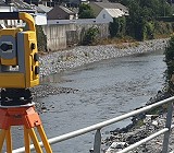
We are experts in recording vertical movement in structures using high precise digital levels. remote areas can be monitored using high precision total Station and targets and high accuracy terrestrial laser scanner to record 3 dimensional movement.
We can provide survey control at all stages of a project, from the initial traverse carried out, through to providing gridlines and datum throughout all stages of construction. We are able to establish survey control networks to national grid, ITM Grid or site local grids.
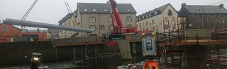
Accurate monitoring and setting out services is a must for any major Civil engineering’s projects.